Travel in lisbon
Lisbon, Portuguese Lisboa, city, port, capital of Portugal, and the centre of the Lisbon metropolitan area. Located in western Portugal on the estuary of the Tagus (Tejo) River, it is the westernmost capital city in continental Europe and serves as the country’s chief port, largest city, and commercial, political, and tourist centre. The city’s name is a modification of the ancient Olisipo (Ulyssipo), and its founding has been attributed to the legacy of Ulysses (Odysseus), the hero of Homer’s Odyssey; to Elisha, purported to have been a grandson of the Hebrew patriarch Abraham; and, more credibly, to Phoenician colonists. Lisbon owes its historical prominence to its natural harbour, one of the most beautiful in the world. Area city, 33 square miles (85 square km). Pop. (2011) city, 547,733; metro. area, 2,821,876; (2021) city, 544,851; metro. area, 2,871,133.
Character of the city
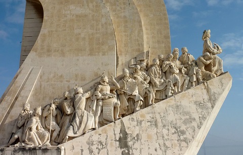
Once a remote outpost on what was thought to be the farthest edge of the known world, Lisbon had established itself as a centre of operations for Portuguese exploration by the 15th century. The city centre was destroyed by an earthquake in 1755 but was rebuilt by the marquês de Pombal. This seagirt city of multicoloured houses and elegant parks and gardens is no longer the capital of a vast overseas empire. It has been reconstructed as a bustling modern metropolis. In fact, Lisbon was designated a European City of Culture in 1994, and in 1998 it hosted the World’s Fair (Expo ’98). That event sparked the city’s biggest renewal project since the rebuilding that followed the 1755 earthquake, including the construction of the six-lane Vasco da Gama Bridge, then the longest bridge in Europe, and other extensive upgrades of the city’s transportation infrastructure. The fair also was the primary catalyst for the construction along the Tagus River of an oceanarium, marinas, hotels, commercial complexes, and entertainment venues.
Despite modernization, Lisbon in many ways retains the air of a 19th-century city. The varinas (fish vendors) who roam the streets dressed in long black skirts still carry their wares in baskets on their heads. Vessels tie up at quays where the clang of trolley cars blends with ships’ horns. At dawn, fishing boats deposit their catch for noisy auction with Lisbon shop owners while the fish vendors wait to fill the baskets they peddle through the streets. Farther inland the fish market gives way to the equally colourful and clamorous fruit and vegetable market. Lisbon’s port maintains an intimacy with its city that was common in the days before steam. Amid the freighters, warships, cruise liners, and ferryboats, a picturesque note is struck by the fragatas of Phoenician origin; these crescent-shaped boats with their striking black hulls and pink sails still perform most of the harbour’s lighterage.
The general outlines of the city remain as they have for hundreds of years. Lisbon is still a city of balconies and vistas. Some of the most striking of the latter can be seen from the miradouros, the terraces maintained by the municipality on seven of its hillsides. (Many Lisboetas, as the people of Lisbon are known, profess their city to have seven traditional hills, like Rome.) For centuries Lisboetas have discussed the symptoms of an affliction they believe to be endemic in their city: saudade (“melancholy”), a state of anxiety tempered by fatalism that is said to be reflected in fado (“fate”), the melodic but deeply emotional folk songs that can still be heard in specific restaurants, mainly in the historic quarters of Alfama and Bairro Alto.
City site
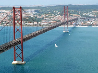
The city lies on the north bank of the Tagus River estuary, about 8 miles (13 km) from the river’s entrance into the Atlantic Ocean. From the ocean upstream to the city, the river is almost straight and about 2 miles (3 km) wide. It is spanned, on the west side of the city, by the 25th of April Bridge. Just east of the bridge, the Tagus suddenly broadens into a bay 7 miles (11 km) wide called the Mar de Palha (“Sea of Straw”) because of the way that it shimmers in the sun. The widest part of the Tagus estuary is spanned by the Vasco da Gama Bridge, which was built to help alleviate traffic on the 25ht of April Bridge. Scenically spectacular, this hill-cradled bay of burnished water lies on a strategic sea route and serves as a busy port, handling much of the trade between Portugal and Spain.
Lisbon is built in a succession of terraces up the slopes of a range of low rolling hills that rise from the banks of the Tagus River and the Mar de Palha northwest toward the Sintra Mountains, whose covering of lush Mediterranean and Atlantic European flora provides an attractive retreat for the city’s population. Sections of the city vary considerably in elevation, especially in the older areas along the water’s edge, which offer splendid views of the river and the low cliffs that line the river’s southern shore. Several geologic faults cross Lisbon and the surrounding region, but, notwithstanding the devastating earthquake of 1755, seismic activity has been limited to slight tremors since the 20th century.
Climate
Lisbon has a mild and equable climate, with a mean annual temperature in the low 60s F (about 17 °C). The proximity of the Atlantic Ocean and the influence of the Gulf Stream mediate the weather conditions throughout the year. January, the coldest month, has an average temperature of 50 °F (10 °C), and in August the temperature seldom exceeds 82 °F (28 °C). Average monthly rainfall ranges from 0.1 inch (3 mm) in summer up to about 4 inches (100 mm) in winter.
City layout
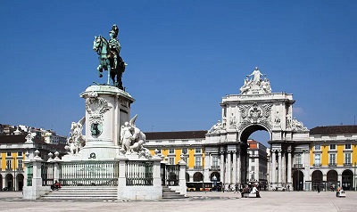
It is traditional for poets to refer to the entwining Tagus as Lisbon’s lover. The river is indeed an ever-present part of the city’s decor, and the official entrance to Lisbon is a broad marble staircase mounting from the water to the vast arcaded Commerce Square (Praça do Comércio). The three landward sides of the square are surrounded by uniform buildings dating from the 18th century. That formal Baroque-inspired layout is pierced by a monumental archway, built a century later, marking the entry north into the central city. In the middle of the square stands a bronze statue of King Joseph I on horseback, an important work by the sculptor Joachim Machado de Castro. Many government offices occupy the buildings that surround Commerce Square.
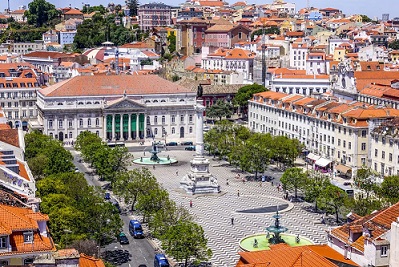
The square lies at the south end of Lisbon’s central district, the Cidade Baixa (“Lower City”). The Baixa was completely rebuilt after the earthquake in 1755 under the supervision of Joseph I’s prime minister, Sebastião de Carvalho, later the marquês de Pombal. The streets are laid out in a grid pattern broken by spacious squares. A series of parallel streets, each named for its original intended occupants (e.g., Rua Áurea [“Golden Street”] for the goldsmiths), runs north from Commerce Square to Dom Pedro IV Square, locally known as Rossio Square. Rossio Square is a traditional centre of activity and the starting point of the city’s main promenade, the wide, gently sloping Avenida da Liberdade. This treelined boulevard leads north from the city centre to Marquês de Pombal Circle, which features a statue of Pombal. The Baixa remains rigorously protected from change, but the four-story buildings that long lined Avenida da Liberdade and its ancillary streets have been almost totally replaced by taller edifices in a bland modern style.
Information cited from https://lisbonlisboaportugal.com/index.html